The Needles Lookout - July 28, 2011
Lookout Details
| Registry Numbers | US 1846, CA 41 (view other lookout sites in United States, California) |
| Date Registered | December 1, 2019 |
| Nominated by | Brad Eells |
| Location |
Sequoia National Forest Tulare County, California |
| Coordinates |
N 36° 06.574' W 118° 29.086' (view using Google Maps) N 36° 06' 34" W 118° 29' 05" N 36.109570° W 118.484767° |
| Elevation | 8,020 ft (2,444 m) |
| Built | 1938 |
| Removed | 2011 (Fire) |
| National Historic Lookout Register | http://nhlr.org/lookouts/us/ca/needles-lookout/ |
| Administered by | US Forest Service - Sequoia National Forest |
Description
Perched atop the rocky outcrop it is named for, Needles Lookout is a popular destination for rock climbers. Built in 1938 to fit the site on an enclosed 7' wooden tower, the 14' x 14' L-4 cab with catwalk has been updated with single pane windows and is reached by a series of stairs ascending the rocky point. It is a good view and radio relay into the Golden Trout Wilderness of the Sequoia National Forest.
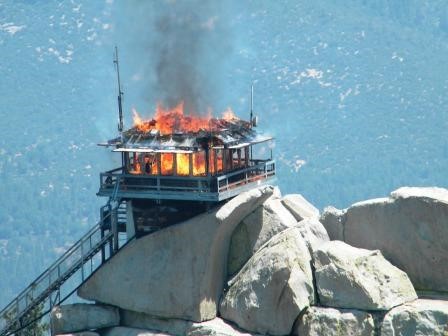
FOR IMMEDIATE RELEASE July 28, 2011 • NEEDLES FIRE LOOKOUT TOWER BURNS(SEQUOIA NATIONAL FOREST): The Needles Fire Lookout Tower, located on the Western Divide Ranger District within the Giant Sequoia National Monument on the Sequoia National Forest was destroyed in a structure fire today. “This is a tragic loss to the District,” stated District Ranger Priscilla Summers. “I’m relieved the person staffing the lookout tower was able to safely evacuate the tower before it burned.” The cause of the fire is under investigation, however it was determined to be a structure fire and not in any way related to the Lion Wildland Fire currently burning in the Golden Trout Wilderness. Firefighters are ensuring the safety of visitors by closing Forest Road 21S05 and trail 32E22 that lead to Needles Lookout, and closure of the area surrounding the rock formation where the lookout was perched. The closure area includes the formation popular for rock climbers known as “The Magician” and will remain closed until the wildland fire resulting from the burning debris has been contained and the area safe for visitors. • The lookout tower was constructed in 1937-38 by the Civilian Conservation Corps atop the rock formation at 8,245 feet. A Forest Service employee, stationed in the tower, was responsible for detecting fires and relaying radio messages to a dispatcher, who in turn sent firefighters and support equipment to extinguish the reported fire. The tower was utilized as this employee’s office as well as their home for the summer months while the lookout was on duty. • Needles overlooked the Kern River Drainage, Mt. Whitney, Olancha Peak, Farewell Gap, and Dome Rock. The tower was the primary communication line for persons in the backcountry where cell phones do not work. The Needles Lookout Tower was one of the most popular places to visit on the Western Divide Ranger District. • “The loss of this historic landmark is significant.” stated Summers. “My immediate concern is for the safety of firefighters who are working to contain the Lion Wildland Fire in the Golden Trout Wilderness who have now lost one of their main lines of communication.” More information will be sent out as soon as it’s available regarding the cause of the fire, availability of the rock formation for visitors, and future plans. • Denise Alonzo, Public Affairs, Western Divide and Hume Lake Ranger Districts, Giant Sequoia National Monument/Sequoia National Forest.
Map
Photos
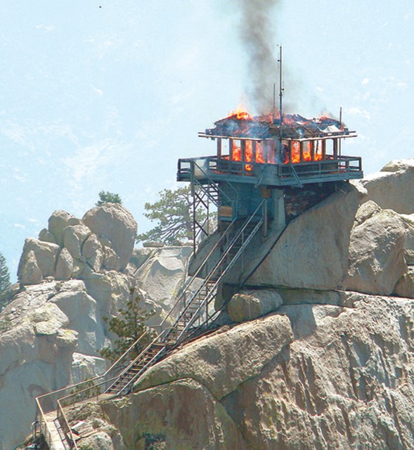
Photo courtesy of Sequoia National Forest
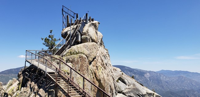
2019
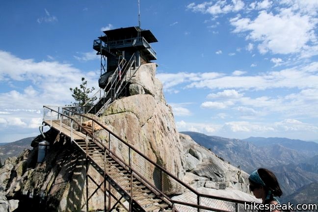
Photo courtesy of www,hikespeak.com