Ashfield Tower Site
US 15, MA 15
Lookout Details
| Registry Numbers | US 15, MA 15 (view other lookout sites in United States, Massachusetts) |
| Date Registered | September 3, 2008 |
| Nominated by | Henry Isenberg |
| Location |
Cran Pond Hill Franklin County, Massachusetts |
| Coordinates |
N 42° 31.800' W 072° 49.180' (view using Google Maps) N 42° 31' 48" W 072° 49' 11" N 42.530000° W 072.819670° |
| Elevation | 1,838 ft (560 m) |
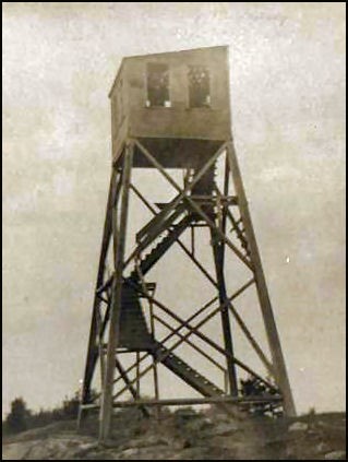
Description
The tower site is located on inaccessable private property. The wooden tower, first operated in 1914, was eventually destroyed in a severe wind storm in the summer of 1918 and was never replaced.
Map
Change Basemap