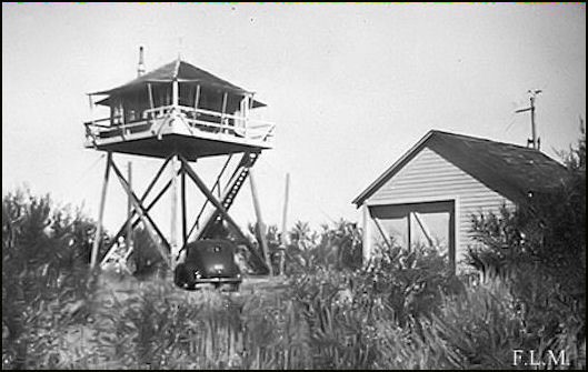
Long Creek Butte Lookout Site
US 1070, OR 428
Lookout Details
| Registry Numbers | US 1070, OR 428 (view other lookout sites in United States, Oregon) |
| Date Registered | June 24, 2011 |
| Nominated by | Ray Kresek |
| Location |
Malheur National Forest Grant County, Oregon |
| Coordinates |
N 44° 39.916' W 119° 02.698' (view using Google Maps) N 44° 39' 55" W 119° 02' 42" N 44.665270° W 119.044960° |
| Elevation | 6,206 ft (1,892 m) |
| Administered by | U.S.Forest Service |
Description
This 20' pole L-4 tower was built in 1933. The pole tower legs were replaced with treated timber legs later on. It's unclear when it was removed.
Map
Change Basemap